 August 4th, 1793, from the DIARY OF MRS. SIMCOE
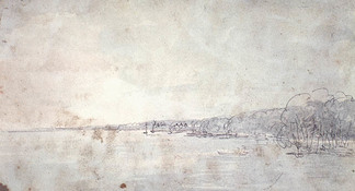
`(...) situated on that part of Toronto bounded by George Street on the west, Parliament Street on the east, Queen Street on the north and Toronto Bay on the south. Early pictures of that part of the city show oak trees along the line of Palace Street, the present Front Street. The spit of land is the present island, in 1793 a peninsula.` Sun. Aug. 4th We rode on the peninsula opposite Toronto, so I called the spit of land, for it is united to the mainland by a very narrow neck of ground. We crossed the bay opposite the camp, and rode by the lake side to the end of the peninsula. NOTE. The party crossed the bay of Toronto from their camp on the shore near the site of the Old Fort, and landed at the present Hanlan's Point, known in the early days as Gibraltar Point. This point is shown in all the Government maps from 1796 as "Gibraltar Point." When Mrs. Simcoe writes later on that the "Onondaga" on her way from Kingston to York was "off Gibraltar Point at York" when passing the present Lighthouse Point, she wrote in error. The peninsula in 1793 joined the mainland at the foot of the present Woodbine Avenue. In 1854 the waters of Lake Ontario broke through and created the present Island. Later the eastern channel was made, now used by the largest lake boats. `We met with some good natural meadows and several ponds. The trees are mostly of the poplar kind, covered with wild vines, and there are some fir. On the ground were everlasting peas creeping in abundance, of a purple color. I am told they are good to eat when boiled, and some pretty, white flowers, like lilies of the valley. We continued our ride beyond the peninsula on the sands of the north shore of Lake Ontario till we were impeded by large trees on the beach. (...)The shore is extremely bold, and has the appear- ance of chalk cliffs, but I believe they are only white sand. They appeared so well that we talked of building a summer residence there and calling it Scarborough.` The party rowed east on Lake Ontario, to the present highlands known from the name given them by Governor Simcoe as Scarborough Heights. The summer residence was not built at the Heights, but a couple of miles up the Don River at the place known as "Castle Frank."
1 Comment
|